- PEMEX conference
- LA County training
- Fixed 5 bugs
- MODFLOW-USG progress including:
- Convert 3D grid to USG
- STR package I/O
- GAG package I/O
- Read solution including head, drawdown, and CCF files
- RCH and EVT package dialogs
- Selecting USG cells
- Displaying symbols in USG
- MODFLOW text output progress including:
- ETS, EVT, GAGE, LAK, MNW, OBS, RCH, SFR, STR, SUB, and UZF packages
- Import MODFLOW well package data from text files
- Updated to latest version of MF2K5
- Pathlines -> Arcs command now works without capture zones
- GeoPDF tests added
- Branched version 9.2
Monday, September 30, 2013
September 2013 Sprint
Monday, September 16, 2013
PEMEX Conference

Alan Lemon from Aquaveo was invited to attend and give a presentation on using GMS for site characterization and flow and transport modeling of impacted sites. The presentation gave some background on the modeling process and how GMS can be used to characterize and model impacted sites. Another lecturer, Dr. Willis Weight, also shared many case studies of applied modeling using GMS. The attendees were particularly impressed with the visualizations demonstrated by Dr. Weight. Many thanks to the conference organizers for the invitation to present. Special thanks to Jorge Chirpas, Paula Andrea Martinez, and Cuauhtemoc Luna for their many efforts before, during, and after the conference.

Wednesday, September 4, 2013
GMS Training at Los Angeles Department of Water and Power
 From August 12 to 15, members of the GMS team at Aquaveo conducted training for the Los Angeles Department of Water and Power (LADWP). The introductory Groundwater Flow and Transport Modeling class was presented to LADWP employees. The class included lectures, demos, hands on exercises, and daily tests to verify that the students could complete modeling problems. We covered MODFLOW, PEST, MODPATH, and MT3DMS. Additionally we talked about borehole data, subsurface characterization, GIS data, and how to integrate this data into groundwater models. The class was a great success. The attendees really appreciated the power and simplicity of GMS and the conceptual modeling approach. Many thanks to the attendees.
Tuesday, September 3, 2013
August 2013 Sprint
- Fixed 10 bugs
- Training course in Los Angeles
- Training course in Mexico City
- MODFLOW-LGR support completed including MODPATH functionality and a second tutorial
- Added DGN (MicroStation) file support
- Added ISTCB1 option support in MODFLOW STR and SFR packages
- Progress on improving native MODFLOW text output
- Progress on open sourcing MODFLOW changes
- Progress on MODFLOW-USG support
- Added MODFLOW option to default starting heads to the grid top elevations
- 3D Grid to shapefile export now lets user pick all, active, or selected data sets to export
Thursday, August 22, 2013
July 2013 Sprint
- Fixed 13 bugs
- Posted a GMS 9.1 update
- More progress on improving native MODFLOW text output
- More progress on open sourcing MODFLOW changes
- MODFLOW-LGR progress
- MODFLOW-USG progress
- Implemented smooth fonts. Fonts will look a lot better
- Removed display of node in the middle of quad elements of a 2D mesh
- Lots of code refactoring taking place
- Attended the ESRI User Conference
Tuesday, July 9, 2013
MODFLOW and MORE 2013
We enjoyed seeing many of you at this year's MODFLOW and MORE 2013: TRANSLATING SCIENCE INTO PRACTICE conference. We had a booth, a couple of posters, and a couple of presentations this year. One poster showed MODFLOW-USG refined grids of different types. The other poster was on MODFLOW Server (images below). Dr. Norm Jones gave a very interesting presentation on Monday on his paper entitled Debating the Long-Term Impact of the Southern Nevada Pumping Project based on consulting work done at Aquaveo. One of Norm's graduate students, Scott Christensen presented on Wednesday on his paper entitled A web-based groundwater mapping and visualization tool using Google Earth which is based on work done partly at Aquaveo and partly at BYU.
 |
| Software demo. Photo courtesy of igwmc. |
 |
| The booth. Photo courtesy of igwmc. |


Friday, June 28, 2013
Isosurface Transparency
For some time GMS has included the ability to have transparent surfaces and transparent contours. These transparent surfaces can come from a TIN, Solid, Cross Section, Mesh, or Grid. The transparency for these surfaces is controlled by adjusting the transparency field in the Material Properties dialog. For contours, the transparency is controlled in the Contour Options dialog.
One of the new features in GMS 9.1 is the addition of transparency for iso-surfaces. The transparency of individual iso-surfaces can be controlled in the Iso-surfaces Options. Below we show the dialog and some iso-surfaces with and without transparency.
One of the new features in GMS 9.1 is the addition of transparency for iso-surfaces. The transparency of individual iso-surfaces can be controlled in the Iso-surfaces Options. Below we show the dialog and some iso-surfaces with and without transparency.
 |
| Iso-surfaces without transparency |
 |
| Iso-surface dialog with transparency control |
| Iso-surfaces with transparency |
Monday, June 17, 2013
June 2013 Sprint
- Fixed 6 bugs
- Fixed problems with the new "Copy to Coverage" command
- Updated help links to wiki pages and added automated tests to report when these get out of date
- Good progress on improving MODFLOW native text output
- Good progress on open sourcing MODFLOW changes
- Overhauled MT3D Basic Package dialog to make setting starting concentrations much easier
- Project-on-the-fly: made new objects get assigned the display projection
- Sped up test coverage analysis
- Started work on FEFLOW mesh import/export
- MODFLOW-LGR progress
- MODFLOW-USG progress
Friday, May 31, 2013
MODFLOW-LGR
The MODFLOW-LGR interface in GMS is almost done. Here are a couple of images showing a nested child grid in plan view and front view.
 |
| MODFLOW-LGR with nested child grid, plan view |
 |
| MODFLOW-LGR with nested child grid, front view |
MODFLOW-USG Progress
The GMS development team has been working on implementing MODFLOW-USG since the documentation was released on May 3, 2013. We have been making good progress. One of the items related to MODFLOW-USG is the ability to work with unstructured grids. The figures below show some of the grids that we have generated with the development version of GMS. We used the same conceptual model and generated a 3D finite element mesh, a 3D structured Grid, and 3D unstructured grids.
We will be at the MODFLOW and more 2013 conference this next week. Come by our booth to learn more about new developments in GMS with MODFLOW-USG. We will also have a couple of posters that we are presenting.
 |
| Conceptual Model |
 |
| Finite Element Mesh - FEMWATER or FEFLOW |
 |
| Finite Element Mesh - FEMWATER or FEFLOW |
 |
| Structure Grid - Traditional MODFLOW |
 |
| Structure Grid - Traditional MODFLOW |
 |
| Unstructured Grid - Nested Grids |
 |
| Unstructured Grid - Nested Grids |
 |
| Unstructured Grid - Quadtree |
 |
| Unstructured Grid - Quadtree |
 |
| Unstructured Grid - Voronoi |
 |
| Unstructured Grid - Voronoi |
Wednesday, May 15, 2013
GMS Training, Olten, Switzerland
Members of the GMS training team recently completed an onsite training class in Olten, Switzerland from April 22-24. It was an intense 3 day training experience. The small class size allowed the students to be very engaged and learn a lot of material in a short period of time. The day following the training was spent working on the client's groundwater modeling project and applying the principles learned in the training. This type of onsite training is available to clients worldwide at very reasonable price. If you are interested in onsite training, including help with your modeling project, contact training@aquaveo.com.


Monday, May 13, 2013
April 2013 Sprint
- Fixed 7 bugs
- Project on-the-fly code improvements
- Training course in Switzerland
- MODFLOW-LGR progress
- MODFLOW-USG progress
- Testing coverage analysis progress
Friday, May 3, 2013
GMS in Beijing, China
Norm Jones and Todd Wood from Aquaveo recently traveled to Beijing, China to conduct a GMS training course on April 23-25 on the campus of Beijing University. The course was co-sponsored by Beijing Water International (BWI) and had 47 attendees from all over China, as well as at least one attendee from Taiwan. BWI translated the GMS tutorial and workshop documents into Chinese and provided translators for each of the lectures.On the Monday (April 22) just prior to the course, Prof. Jones participated in a one-day workshop at Beijing University on the Arc Hydro Groundwater (AHGW) data model and tools. This workshop was hosted by Chunmiao Zheng who is now a faculty member at Beijing University. The workshop also featured a presentation by Yingying Yao who is one of Prof. Zheng's PhD students. Yingying presented the results of a major groundwater study involving the Heihe River Basin in North Central China. Yingying used AHGW to compile and manage the groundwater data, which she then used to construct a detailed 3D model of the site geology. She also built a 3D groundwater model using GMS. The workshop also included presentations by the Chinese Geologic Survey.
Groundwater is a focus of increasing attention in China recently, partly due to some high profile cases involving groundwater contamination being featured in the media. The Chinese government has recently indicated that maintaining groundwater quality and sustainability will be a strategic emphasis in the coming years. We hope that both GMS and AHGW can assist in that effort.

Monday, April 8, 2013
March 2013 Sprint
- Fixed 6 bugs
- Released GMS 9.1 beta. See the What's New.
- Added lots of user-request features, including:
- Snap Boreholes to TINs command
- Exporting material names/colors/patterns/tranparency
- Computed flow and Residual flow columns added to the map attribute table for flow observations
- Iso-surface transparency
- Copy feature objects to another coverage
- Activate / Inactivate scatter points command
- MODFLOW-LGR progress
- MODFLOW-USG progress
- New tutorials created:
- MODFLOW - Transient Calibration Pump Test
- MODFLOW - Transient Observation Data
- PHT3D - Ion Exchange And Surface Complexation
- PHT3D - Transport And Mineral Reactions
- Project on-the-fly interface improvements
- Progress on code coverage analysis with tests
- Much code cleanup and refactoring
Thursday, March 14, 2013
PHT3D
GMS 9.1 will support PHT3D.
PHT3D is a multicomponent transport model for three-dimensional reactive transport in saturated porous media developed and maintained by Henning Prommer and Vicent Post. PHT3D is a combination of MT3DMS and PHREEQC-2. The PHREEQC allows for a variety of low temperature aqueous geochemical reactions.
GMS will support PHT3D as an add-on to the MT3DMS interface. In addition to the samples that come with the PHT3D documentation, users can create their own geochemical reactions and use the GMS interface to set up their model. GMS can parse the PHREEQC database file, so any valid PHREEQC database can be used to set up a model. Below are a few screen shots from the interface.
After selecting PHT3D as the transport model the user can select the Define Species button and the following dialog will come up.
From this dialog the user can set basic PHT3D options. By selecting from the list on the left of the dialog the user can enter various options for the different types of species that are included in the model.
Notice at the top of the dialog the user can choose to select a PHREEQC database file. The species are partially defined by the contents of the PHREEQC database file. GMS reads the PHREEQC database and makes the species contained therein available to the user. The user can also select a PHREEQC-2 interface package file. When an interface package file is chosen GMS assumes that the PHREEQC database file is in the same directory with the name pht3d_datab.dat. The images below show some of the options for entering data related to the species.
PHT3D is a multicomponent transport model for three-dimensional reactive transport in saturated porous media developed and maintained by Henning Prommer and Vicent Post. PHT3D is a combination of MT3DMS and PHREEQC-2. The PHREEQC allows for a variety of low temperature aqueous geochemical reactions.
GMS will support PHT3D as an add-on to the MT3DMS interface. In addition to the samples that come with the PHT3D documentation, users can create their own geochemical reactions and use the GMS interface to set up their model. GMS can parse the PHREEQC database file, so any valid PHREEQC database can be used to set up a model. Below are a few screen shots from the interface.
 |
| MT3D Basic Package dialog allows selection of PHT3D as transport model |
 |
| PHT3D Options dialog |
 |
| PHT3D Options dialog with no database file selected |
 |
| Equlibrium Species |
 |
| Kinetic Species |
 |
| Equilibrium Minerals |
Monday, March 4, 2013
Zoom to Selections, Locate Selections
Two new commands were added at GMS 9.0: Edit | Locate Selections and Display | Zoom To Selections.
Locate Selections
The Locate Selections command is in the Edit menu and results in an animated rectangle which starts from the borders of the graphics window and zooms in to surround whatever is currently selected (grid cells, boreholes etc). This helps you identify where your selections are.
Zoom To Selections
The Zoom To Selections command is in the Display menu and causes the graphics window to be framed around the currently selected objects (grid cells etc).
These commands can make working with large amounts of data a little easier.
 |
 |
February 2013 Sprint
- Taught training course in Egypt
- Fixed 6 bugs
- Finished PHT3D interface which is now being reviewed.
- MODFLOW-LGR progress
- MODFLOW-USG progress
- Completed design for MODFLOW-CFP
- Added transient TINs with Map -> MODFLOW
- Much miscellaneous code refactoring
Thursday, February 14, 2013
Advanced GMS Training, Cairo, Egypt
Dar Al-Handasah hosted an Advanced GMS Training Course from February 6-12, 2013.

The class comprised 6 full days of training. A broad range of subjects were covered including: creating MODFLOW models by directly editing 3D Grid, MODFLOW conceptual models, GIS data integration with groundwater models, subsurface modeling, model calibration, PEST, Parallel PEST, SVD-Assist, MODPATH, Transport Modeling with MT3DMS, Stochastic simulations using parameter distributions, Stochastic simulations using TPROGS material sets, Stochastic simulations using PEST Null Space Monte Carlo, SEAWAT, and MODFLOW-CFP. Most of the time in the training was passed using GMS to solve case study problems. Many of the case studies were based on Woburn, MA (the subject of the book and film A Civil Action). Groundwater data for Woburn can be found here.

The students really appreciated all of the time spent practicing using GMS to solve a variety of groundwater problems. They especially appreciated how powerful, intuitive, and easy GMS was to work with. By the end of the first day the students were able to create MODFLOW models with almost no help from the instructor.


Aquaveo wishes to express many thanks to Dr. Abdel-Rahman Abdel-Raouf of Dar Al-Handasah for helping to organize the class.

The class comprised 6 full days of training. A broad range of subjects were covered including: creating MODFLOW models by directly editing 3D Grid, MODFLOW conceptual models, GIS data integration with groundwater models, subsurface modeling, model calibration, PEST, Parallel PEST, SVD-Assist, MODPATH, Transport Modeling with MT3DMS, Stochastic simulations using parameter distributions, Stochastic simulations using TPROGS material sets, Stochastic simulations using PEST Null Space Monte Carlo, SEAWAT, and MODFLOW-CFP. Most of the time in the training was passed using GMS to solve case study problems. Many of the case studies were based on Woburn, MA (the subject of the book and film A Civil Action). Groundwater data for Woburn can be found here.

The students really appreciated all of the time spent practicing using GMS to solve a variety of groundwater problems. They especially appreciated how powerful, intuitive, and easy GMS was to work with. By the end of the first day the students were able to create MODFLOW models with almost no help from the instructor.


Friday, February 1, 2013
On-the-fly projection
On-the-fly projection is one of the many new features in GMS 9.0. On-the-fly projection means that individual objects (coverages, grids, images etc) can define their own projection. If they do, they will be reprojected to a common display projection when drawn. Thus, if you have data defined in different coordinate systems (state plane, UTM etc) you can now import that data as is and it will all be drawn in the right place. The only necessity is that a .prj file accompanies the data or that you specify the projection in GMS after importing.
Objects don't have to define their own projection. If they don't, GMS assumes the object's projection is the same as the display projection and just draws it using the object coordinates without performing any reprojection.
There are a few rules with on-the-fly projection. If an object's projection doesn't match the display projection it cannot be edited. You can, however, change the display projection to match the object's projection, edit the object, and then change the display projection back if you like.
Another rule is that if a grid (2D or 3D) defines it's own projection, the display projection must match the grid projection. GMS will force them to match. Furthermore, all grid objects (2D, 3D and the grid frame) must either define no projection, or all define the same projection.
The Projection command was moved from the Edit menu to the Display menu and renamed Display Projection.
The status bar was changed to show the current display projection as well as the latitude and longitude whenever the display projection is a global projection:
A standard "Projection" sub-menu was added to the right-click menu of every object. This menu has commands to set the object's projection, set the display projection to match the object's projection, reproject the object, and transform the object.
The projection dialog was modified so that it now says "No projection" instead of "Local projection". The difference is subtle, but we felt the new verbage was more accurate.
Objects don't have to define their own projection. If they don't, GMS assumes the object's projection is the same as the display projection and just draws it using the object coordinates without performing any reprojection.
There are a few rules with on-the-fly projection. If an object's projection doesn't match the display projection it cannot be edited. You can, however, change the display projection to match the object's projection, edit the object, and then change the display projection back if you like.
Another rule is that if a grid (2D or 3D) defines it's own projection, the display projection must match the grid projection. GMS will force them to match. Furthermore, all grid objects (2D, 3D and the grid frame) must either define no projection, or all define the same projection.
GUI changes
A number of changes in the GUI were made to support the new projection functionality.The Projection command was moved from the Edit menu to the Display menu and renamed Display Projection.
The status bar was changed to show the current display projection as well as the latitude and longitude whenever the display projection is a global projection:
 |
| Status bar showing lat/lon and current display projection. |
A standard "Projection" sub-menu was added to the right-click menu of every object. This menu has commands to set the object's projection, set the display projection to match the object's projection, reproject the object, and transform the object.
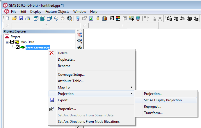 |
| Standard Projection sub-menu added to all objects. |
 |
| New Projection dialog. |
Thursday, January 31, 2013
January 2013 Sprint
- Fixed 8 bugs
- MODFLOW-LGR progress
- PHT3D progress
- MODFLOW-USG progress
- Start of test coverage analysis
Thursday, January 3, 2013
December 2012 Sprint
- Added some new images to the Image Gallery
- Released GMS 9.0 out of beta
- Fixed some raster legend issues
- Progress on MODFLOW-LGR
- Progress on PHT3D
- Progress on unstructured grids
Subscribe to:
Posts (Atom)