Wednesday, December 12, 2012

Multiple CAD Files

In response to a feature request, starting at GMS 9.0, multiple CAD files can be loaded into GMS at the same time. In the Project Explorer the changes look like this:
Old
New

Also, CAD files are no longer saved when the project is saved. Instead they are treated as externally linked files and only the links are saved.

One other change to CAD file support was the addition of a Properties dialog that shows the CAD file name and path, number of layers, extents, file version, and map projection.

Friday, November 30, 2012

November 2012 Sprint

  • Fixed 8 bugs
  • Released GMS 8.3.7
  • Took GMS 9.0 out of beta. It is now the current version.
  • PHT3D support started
  • MODFLOW-LGR support - major progress
  • Overhauled how framing is done in dev. Framing will be more accurate and the code is much simpler.
  • Separated the registry paths for 32 and 64 bit versions in dev
  • Created two new transient tutorials for dev
  • Wiki -> Help progress
  • Added more bitmaps to pop-up menus in dev
  • Added basic code coverage analysis for GUI tests

Thursday, November 29, 2012

PEST Null Space Monte Carlo


GMS supports multiple methods for performing stochastic simulations such as parameter randomization and indicator simulations. In version 9.0 we have added support for another stochastic method: the PEST Null Space Monte Carlo (NSMC) method. The NSMC method allows you to generate multiple calibrated models with different sets of parameters.

There is always a significant amount of uncertainty associated with a groundwater model.  This uncertainty can be associated with the conceptual model or the field data or the input parameters of the model.  Some model parameters, such as hydraulic conductivity, are particularly prone to uncertainty.  This uncertainty can be reduced by calibrating a model to observation data (monitoring wells, stream flows, etc.).  However, even a well-calibrated model can have significant uncertainty associated with it.

The challenge with a groundwater model is to explore the uncertainty while maintaining a calibrated model (good fit with field measured values). The generation of model input parameters that will respect calibration constraints is a time consuming matter since a parameter estimation exercise must be undertaken for each new set of parameters. However, two tools provided with PEST greatly reduce the amount of time required to perform calibration-constrained Monte Carlo analysis of a groundwater model. The first is the use of SVD-Assist in the calibration process. The second is the pre-calibration null space[1] projection of differences between the stochastic parameter fields and the simplified “calibration parameter field” that is decreed to “calibrate the model”. By using both of these utilities it is possible to obtain parameter sets that respect both the stochastic variability of the subsurface as well as the field measured values; this is accomplished with only a handful of runs per realization.

The results from a PEST NSMC run are illustrated in the figures below where we have two different hydraulic conductivity fields and yet the heads at the observations points remain within acceptable error limits.

Simulation 1
Simulation 2


Using PEST NSMC is very easy in GMS. Two new tutorials have been developed to teach users how to use the NSMC method in GMS. You can find the tutorials in the GMS Learning Center.


[1] The null space is comprised of individual parameters, or combinations of parameters, that have no effect on model outputs under calibration conditions. These combinations of parameters can therefore be added to any set of parameters which calibrates the model, to produce another set of parameters which also calibrates the model.

Tuesday, November 6, 2012

October 2012 Sprint

  • Fixed 16 bugs
  • Branched GMS 9.0 code base
  • Held a GMS training course in Australia
  • Initial investigation of MODPATH 6.0 support
  • Added a Z Values -> Data Set command for 2D objects
  • Changed rasters so that interpolation using a raster catalogs results in one data set and interpolation from multiple selected rasters results in multiple data sets
  • Unstructured grids are now rendering in GMS
  • Cleaned up a lot of help links on the wiki and help buttons in GMS
  • Switched scatter points to use the standard Contour Options
  • Added exporting of 3D grids to a VTK file for use in ParaView
  • Progress on support for multiple grids
  • Progress on wiki to dynamic help file

Monday, November 5, 2012

GMS Training - Perth, AU - Recap

We just completed a training course in Perth, Australia from October 23-26. The course was a great success. Users from all over Australia came together to learn how to use GMS to solve their ground water modeling problems. We even had a user fly in from Japan.


Many thanks to our friends at SRIT (Geoff and Glenys Flight) for organizing the course.
SRIT also had a drawing for some prizes for our course attendees.


Wednesday, October 24, 2012

Rasters

A new image object type which we are calling a "raster" has been added with GMS 9.0. Rasters are essentially images with elevations - an image that includes a color value and a data value at each pixel. GMS uses the raster object type to support DEM files, and a large variety of DEM file types can be imported into GMS as rasters.


Rasters can be displayed as 2D images, with or without shadows, or as a 3D point cloud without shadows. Both options are very fast and memory efficient. Four different shaders, or color ramps, can be used to show  variations in elevation.

Rasters can be interpolated to all other GMS object types as well as to MODFLOW layer data (similar to 2D scatter points). They can be created inside GMS from 2D scatter points.

A wiki page has been created to document the raster interface in GMS and a new Raster tutorial will be available when GMS 9.0 is released.

Friday, October 12, 2012

Online Maps

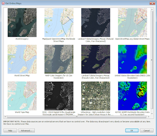
"Online maps" are a new feature added at GMS 9.0. Online maps are free raster data (aerial photos, street maps, elevation data etc.) from sources such as ESRI and OpenStreetMap.org (other sources can be added via an Advanced button). If you have an internet connection, online maps can be displayed in the background in GMS and are updated automatically as you zoom in and out or pan the view. The imagery is automatically projected to the current display projection and displayed in real world coordinates. An online map can be exported and saved locally with your project.

Online maps provide an easy way to locate and start a new modeling project. For more information, see the wiki.

Get Online Maps dialog.

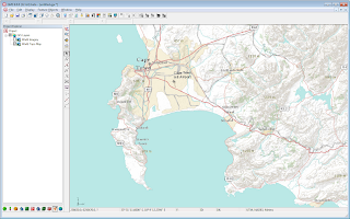
GMS showing a World Topo Map Online Map.

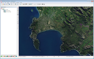
GMS showing a World Imagery Online Map.

Monday, October 1, 2012

September 2012 Sprint Highlights

Some of the more interesting accomplishments from the September 2012 sprint:
  • Fixed over 18 bugs
  • Changed the Virtual Earth Locator tool to start where the graphics windows is currently
  • Project-on-the-fly finished except for tutorial
  • Rasters finished. Added display of elevation under mouse, exporting of more formats, legend fixes, local (non-global) projections, 3D point cloud display
  • Horizons -> Solids using rasters implemented
  • Added node xyz coordinates to arc attribute table
  • Progress on Wiki -> Help
  • GMS 9.0 beta ready
  • MODFLOW-LGR HDF5 conversion done
  • MODFLOW version, precision, parallel options saved in super file

GMS Now Includes Support for the PCGN Solver

GMS 9.0 includes support for the PCGN solver (Preconditioned Conjugate Gradient Solver with Improved Nonlinear Control).  The PCGN solver is included in MODFLOW-2005.  The PCGN solver was created to provide more options for models with poorly converging non-linear problems.  A detailed description of recommended PCGN input values can be found in the USGS Online Guide to MODFLOW.

The PCGN solver has been parallelized and can result in faster model runs for large models when the MODFLOW Parallel preference is enabled in the GMS Preferences dialog.

Tuesday, September 25, 2012

SUB - Subsidence and Aquifer-System Compaction Package

GMS version 9.0 has added support for the SUB package in MODFLOW.  The SUB package was developed by the USGS to simulate aquifer compaction and land subsidence.  The SUB package simulates compaction of interbeds including both elastic (recoverable) and inelastic (not recoverable) compaction. It also includes the ability to simulate interbeds where drainage from the interbed is immediate (no-delay) or delayed.


In GMS you can add interbeds and set interbed attributes using the conceptual model interface.  You can also add and edit interbeds through a grid interface.  The grid interface also includes the ability to setup SUB package output.  When SUB package vertical displacement has been set to be saved to a file, a VerticalDisplacement data set is added to the model solution in the GMS project explorer as shown above.


To learn more about using the SUB package in GMS, a new tutorial will be available in the GMS learning center when GMS 9.0 is released. Documentation on the wiki is available now.

August 2012 Sprint Highlights

Some of the more interesting accomplishments from the August 2012 sprint:
  • Fixed over 14 bugs
  • Fixed dragging display when using computers with integrated graphics 
  • Implemented Project-on-the-fly for all modules and objects
  • Added import/export support for several DEM/Raster file types including:
    • GeoTIFF
    • Arc/Info ASCII Grid
    • BIL
    • USGS DEM
    • FLOAT/GRID (NED)
    • Surfer Ascii Grid Files
    • DXF
  • Added interpolation from raster catalogs
  • Added legends for rasters
  • Added user defined min/max for scatter -> raster
  • Added ability to open multiple files at once
  • Added drag-and-drop to the entire GMS window, not just the Graphics Window
  • Reconfigured the XYZF and IJK/ID panes to accomodate Lat/Lon and projection
  • Added mouse tracking while using the pan and rotate tools
  • Finished some tutorials: null-space Monte Carlo and SUB package

Friday, August 31, 2012

MODFLOW GAGE Package Support

MODFLOW Gage package (GAGE) support has been added to GMS 9.0.  The Gage package provides the ability to create gage stations for a given lake ID or SFR stream reach. When the simulation is run, time series output is generated for each gage station. GMS support for the package includes the ability to add gage stations to a MODFLOW simulation. When a MODFLOW solution is read, the output gage files are listed in the solution folder.  Gage output files can be viewed by double clicking on the file in the solution folder.  GMS also supports the ability to generate gage plots.


Monday, August 6, 2012

July 2012 Sprint Highlights

Some of the more interesting accomplishments from the July 2012 sprint:

  • Released GMS 8.3! See what's new!
  • Fixed over 20 bugs.
  • Upgraded to the latest MODFLOW executables.
  • Finished a MODFLOW STR package tutorial.
  • Finished the SUB package interface, including a new tutorial.
  • Put back exporting a map file.
  • More progress on rasters including two new tutorials.
  • Implemented "Stochastic Predictive" mode - populating parameter randomization stochastic simulations with results from a null space Monte Carlo run.
  • Added statistical analysis for parameter arrays (not just the head data).
  • Created a list of videos sorted by category on the GMS YouTube playlist.
  • Implemented the PCGN2 solver.
  • Made progress on the PHT3D interface design.
  • Posted a PDF snapshot of the wiki for GMS 8.3.
  • Made progress on project-on-the-fly

Friday, July 13, 2012

MNW2 - Multinode Well 2 Package

GMS version 8.3 has added support for the MNW2 package in MODFLOW. This package is an update to the MNW1 package. In addition to supporting the capabilities of the MNW1 package, the MNW2 package can also calculate additional head changes due to partial penetration affects, flow into a borehole through a seepage face, changes in well discharge related to changes in lift for a given pump, intraborehole flows with a pump intake located at any specified depth in the well, and improved capability to simulate nonvertical wells.

Take a look at the GMS learning center here for new tutorials with the MNW2 package.


GMS supports manually creating/editing MNW2 boundary conditions directly on the MODFLOW grid.

In addition, the conceptual modeling tools have been updated to support the MNW2 package.


GMS continues to add support for MODFLOW packages. Look for more packages in the near future. Happy modeling!

Monday, July 2, 2012

June 2012 Sprint Highlights

Some of the more interesting accomplishments from the June 2012 sprint:
  • Fixed over 10 bugs
  • Switched all model code to use the newer version of Visual Fortran
  • Taught a GMS training course in France
  • Good progress on the MODFLOW SUB package interface
  • Updated MODFLOW-NWT with the latest from the USGS
  • Overhauled the MODFLOW menu to make it more usable
  • Implemented more raster features including a raster catalog and virtual earth dialog buttons
  • Added text in the MODFLOW Global Options dialog to show what MODFLOW executable will be used
  • Added support for multiple CAD files
  • Created a CAD properties dialog
  • Overhauled how z values relate to the active data set for TINs, 2D meshes and 2D scatter points to make it simpler and easier
  • Started displaying the current project and the latitude and longitude at the bottom of the graphics window

May 2012 Sprint Highlights

Some of the more interesting accomplishments from the May 2012 sprint:
  • Fixed over 19 bugs
  • Overhauled the MODFLOW ccf file reader to be more generic
  • Much progress on the MODFLOW SUB package
  • Updated MODFLOW 2005 executable with the latest changes from USGS
  • Mostly finished phase 1 of PEST Null Space Monte Carlo support
  • Began adapting MODFLOW LGR to GMS format
  • Finished several raster features including interpolation and conversion to/from other object types
  • Added more "Open containing folder" commands where they were needed
  • Made it so we just link to CAD files instead of saving them with the project
  • Added duplication of MODFLOW array data in the Project Explorer
  • Removed the interface for flow observations with the SFR package since MODFLOW doesn't support this
  • Added commands to Expand / Collapse most items in the Project Explorer
  • Split the MODFLOW conceptual model tutorial into two separate tutorials
  • Finished the MODFLOW MNW2 package tutorial for non-vertical wells and pump capacity
  • Added more bitmaps in the menus and made the old ones look better

Wednesday, June 27, 2012

GMS Training, Nancy, France - Recap


From June 12-15, 2012, members of the GMS development team and Dr. Norman Jones taught a GMS training course in Nancy, France at the Institut National Polytechique de Lorraine.

Many thanks to Dr. Fabrice Golfier for helping to organize the class. Individuals from Europe and the Middle East were able to come together and learn about the most advanced groundwater modeling software available, GMS. Once again the course attendees commented on the many powerful features available in GMS and how they could use the software in their work. Thanks to all those who attended.

Dr. Norm Jones teaching a lecture during the course

Tuesday, May 15, 2012

Velocity vectors

Beginning with version 8.2, GMS can now generate velocity vectors using information from the MODFLOW cell-to-cell flow (ccf) file. Several pieces of information are required to compute groundwater flow velocity from a MODFLOW model. First, the amount of flow in the I, J, and K directions for a given cell is read from the CCF file. If a particular cell contains a boundary condition that is withdrawing water (such as a well) then the flow in the I, J, and K directions is decreased based on the amount of flow leaving the cell through the boundary condition. Next, the saturated area is calculated in the I, J, and K directions. For the I and J directions it is necessary to use the top and bottom elevations that are specified in MODFLOW's discretization package. If the particular cell is part of an unconfined aquifer then it is also necessary to get the computed head for the cell as the computed head is most likely below the top elevation of the cell. The final piece of information necessary for the calculation is porosity. Although porosity is not part of the MODFLOW inputs, using GMS you can specify porosity on a per cell basis. Once the flows, areas, and porosity are assembled the groundwater flow velocity is computed using the following equations:

Velocity.I = Flow.I / (SaturatedArea.I * porosity)
Velocity.J = Flow.J / (SaturatedArea.J * porosity)
Veloctiy.K = Flow.K / (Area.K * porosity)

To create a velocity vector data set from a MODFLOW CCF file in GMS you simply right click on the CCF data in the GMS Project Explorer and select the CCF -> Velocity Vectors command.
Conversion from CCF to Velocity Vectors

Once you have a vector data set you can adjust the display of the vectors by going to the Display Options dialog for the 3D grid and turning on the Vectors check box. If you select the Options button next to the Vectors check box you have further control over the display of the vectors.
Velocity Vector Plot in GMS

Monday, April 30, 2012

April 2012 Sprint Highlights

Some of the more interesting accomplishments from the April 2012 sprint:
  • Fixed over 21 bugs
  • Held a training course in Orem, Utah
  • Completed MODFLOW SUB package to about 40%
  • Added support for all file formats supported by Global Mapper
  • Added dynamic online imagery via Global Mapper
  • Identified the changes needed to support the SFR2 inputs used with UZF
  • Switched next version number form 8.4 to 9.0
  • Completed most of the work needed for PEST null space Monte Carlo support with RANDPAR
  • Added the ISTCB2 option in the STR package
  • Added a model checker for the SFR package
  • Added an option to only save the groundwater data in the UZF package
  • Added wells in the MT3D TOB package so it tracks (and we can plot) mass vs. time
  • Added all array-based parameter types to the set of those that can use pilot points with PEST
  • Made the gage folder in the MODFLOW solution start out collapsed by default
  • Added the GMS version number to the main window title
  • Renamed "Convergence Options" to "PEST ASP Package" to help identify what it is
  • Switched to new round logos
  • Made improvements to the pilot points, transient, and gage tutorials
  • Continued improvements to the wiki

Monday, April 2, 2012

March 2012 Sprint Highlights

Some of the more interesting accomplishments from the March 2012 sprint:
  • Posted GMS 8.3 beta
  • Added two new videos to our YouTube channel on regional to local model conversion and contour options
  • Fixed over 10 bugs
  • Added a machine to help with nightly testing
  • Added a few new testimonials
  • Started on the PHT3D interface design
  • Moved SFR outputs related to ISTCB2 to a separate CCF file so they don't get included in the flow budget.
  • Fixed the Check For Updates command to warn if the maintenance has expired to avoid downloading an update that can't be used.
  • PEST Null space Monte Carlo progress
  • Came up with a fix for broken images when converting the wiki to OpenOffice
  • Designed Global Mapper dynamic images
  • Finished adding support for the MODFLOW Gage package
  • Added a new Measure tool
  • Added new Locate Selections and Zoom To Selections commands
  • Simplified the MT3D Sink & Source Mixing Package dialog
  • Enhanced the model checker and added tests for MT3D SSM, RCT and ADV packages.
  • Held a training course in Mexico City
  • Made several improvements to the Model Calibration tutorial
  • Started splitting the Conceptual Model Approach tutorial into two
  • Made exported shapefiles include a projection (.prj) file whenever the projection is not local

Monday, March 12, 2012

Training Mexico City, Mexico

A GMS training course was held from March 5-8 in Mexico City, Mexico. Alan Lemon of the GMS development team and Dr. Willis Weight of Carroll College, Montana taught the course.

The course was well attended. More than 20 people attended the course. There was a wide variety in the amount of experience with groundwater modeling. Some attendees had been building models for years, while others were relatively new to groundwater modeling. Also, the attendees came from many different backgrounds including: professors at universities, consultants, and students. Based on the comments submitted after the course, the attendees felt like they all learned something valuable that they could use in their work. Many attendees commented on how much easier it was to build models using GMS than other MODFLOW preprocessors. They appreciated using the conceptual model approach and having their data independent of a MODFLOW grid.

Thanks to Jorge Chipres and Catalina Morato for their efforts in organizing the course.

Thursday, March 1, 2012

Exporting 3D Grids to Shapefiles

In GMS 8.2 we added the ability to export a 3D grid to a shapefile. All layers of the grid are exported, along with the active data set and the grid cell activity (IBOUND) and data set activity (dry cells) if they exist. Here is the list of the attributes that get exported:
  • cell ID
  • cell I
  • cell J
  • cell K
  • grid cell activity
  • active scalar data set values
  • active data set activity (if it exists)
A simple definition query using the grid cell activity and K fields can be created in ArcMap to see one layer of the grid at a time. For example, the following figure shows the head solution on the third layer of the grid from the lake package tutorial as a shapefile in ArcMap.


Tuesday, February 28, 2012

MODFLOW-NWT Interface

With the release this week of GMS 8.2, GMS includes support for MODFLOW-NWT including the UPW package and NWT solver. Compiled versions of the MODFLOW-NWT executable are included with the GMS installer, including versions for 64 bit and double precision. A new tutorial covering the NWT interface has been added and is included in the tutorial installer and is also available via the learning center.


Monday, February 27, 2012

February 2012 Sprint Highlights

Some of the more interesting accomplishments from the February 2012 sprint:
  • Released GMS 8.2
  • Finished GMS 8.3 beta
  • Flow vector calculations are now velocity vectors
  • Design for MODFLOW-CDSS
  • Gage package progress
  • PEST Null space Monte Carlo progress
  • Fixed over 36 bugs
  • Created GUI tests for the MNW2 package, FEMWATER transport tutorial, Map -> 3D scatter, 2D Scatter -> 3D Scatter and other features
  • Progress on MODFLOW-LGR design
  • MT3D heat transport tutorial
  • Documented versions of third party software on the wiki

Monday, January 30, 2012

MODPATH Updates Coming Soon


GMS 8.2 includes improvements to the MODPATH model interface. The biggest change is that GMS saves the MODPATH files with the project, and reads the pathline solutions when reading the project. This is especially helpful for transient MODFLOW models with large grids where MODPATH can take a considerable amount of time to run. The option to run MODPATH automatically now only works for steady state models. This option is available by selecting "General Options" in the MODPATH menu. The toggle is near the bottom of the dialog.

A second added feature for GMS 8.2 is that MODPATH pathlines can now be converted to a coverage. This is available by selecting "Pathlines -> Arcs" from the MODPATH menu.

Another feature that will be coming in GMS 8.3 is that MODPATH pathline colors can be set based on the MODPATH zone code for the grid cell the path line is crossing. An example is shown in the screenshot below. For this model, each grid layer has a different MODPATH zone code, so the pathlines change color as they pass through different layers. This option will be available by selecting Display Options from the MODPATH menu and then selecting "Cell zone code" from the color popup menu.


Friday, January 27, 2012

January 2012 Sprint Highlights

Some of the more interesting accomplishments from the January 2012 sprint: 
  • Fixed over 18 bugs
  • Finished 8.3 installer and separated tutorials from main program
  • Created two new videos on our YouTube channel
  • Finished about 99% of our continuous integration system
  • Finished MODFLOW MNW2 package interface
  • Updated MODFLOW NWT to the latest version
  • Implemented tech support notifications for the new "Report A Bug" feature
  • Added support for MT3D steady state stress periods
  • Overhauled the CCF -> Vectors feature to actually give velocity vectors (long overdue). Pushed it to GMS 8.2.
  • Created some more SEAWAT tutorials
  • Started on creating more MNW2 tutorials
  • Hooked up the dialog help buttons to the CHM file.
  • Found and fixed some memory looks.
  • Designed the interface for the MODFLOW SUB Package
  • Added MODPATH starting locations -> 3D scatter and vice versa
  • Added Shapefile -> 3D Scatter and vice versa
  • Added some SEEP2D images to the Image Gallery
  • Got the intermediate tests passing for Visual Studio 2010
  • Made the Community Edition work without a license


Thursday, January 19, 2012

ZONEBUDGET


GMS has an extensive tool set for working with flow budget information from MODFLOW. GMS is the only package that reports flow budget information on GIS features. For example, if polylines or polygons were used to create drain boundary conditions in MODFLOW then GMS will report the flow into or out of the model from the polyline/polygon. For some time now, GMS has allowed users to view flow budgets for selected sub-areas of their models as well as the ability to assign zone budget ids to cells and extract flow budget information.

Beginning with GMS 8.2, we will now include an interface to USGS ZONEBUDGET. This tool is accessed by selecting the Flow Budget menu command in the MODFLOW menu. There is a USGS ZONEBUDGET tab available in the dialog. The user can set up their input options and then there is a button to launch ZONEBUDGET. The input and output files for ZONEBUDGET are written to the same directory where the MODFLOW Cell-to-cell flow file is located.

There is also a new tutorial available that shows the various ZONEBUDGET options. Go to the GMS Learning Center on http://www.aquaveo.com/gms-learning to download the tutorial.

A video that demos the ZONEBUDGET feature is available on the Aquaveo youtube channel.

Tuesday, January 3, 2012

December 2011 Sprint Highlights

Some of the more interesting accomplishments from the December 2011 sprint:

  • Fixed over 14 bugs
  • Finished 8.2 installer
  • Greatly improved the MODFLOW water table display in side view and got it working with MODFLOW-NWT solutions
  • Posted the first beta of GMS 8.2
  • Finished about 80% of our continuous integration system
  • Finished about 80% of the MODFLOW MNW2 package interface
  • Created an initial chm help file from the wiki. Doc-To-Help has a couple of blog posts about it
  • Created initial support for opening the chm help file to a particular topic from a dialog
  • Implemented a user request to change the MODPATH pathline color as it passes through different zones
  • Added a "Report a Bug" command to the Help menu
  • Added some user testimonials to aquaveo.com

November 2011 Sprint Highlights

Some of the more interesting accomplishments from the November 2011 sprint:
  • Fixed over 5 bugs
  • Updated the tutorials for 8.2
  • Designed and implemented the ZONEBUDGET interface (available in 8.2)
  • Added registration components for MODFLOW-NWT and ZONEBUDGET
  • Created GUI tests for MODFLOW-NWT and ZONEBUDGET
  • Branched 8.2
  • Created the online license manager for 8.2
  • Created an automated nightly build that's posted and available at aquaveo.com
  • Completed about 40% of the MODFLOW MNW2 package interface
  • Designed a GSFLOW interface
  • Started designing the PEST Null space Monte Carlo interface
  • Got chapters working in wiki to ODT conversion
  • Started creating a FEMWATER transport tutorial